
In
another article, we went to a great deal of trouble to plan a cross-country
flight of about an hour and a half. Things don't always go according to
plan, so we need to be able to make some adjustments while en route. The
trip was planned from Bridgeport, Connecticut, to Bloomsburg, Pennsylvania
The westbound route is basically direct, with a slight dogleg to keep some distance from the New York terminal airspace. Let's take a look at some things that could go awry, and how to deal with them.

Northwestern New Jersey has no forecasting stations, but the Kittatinny Mountains and the Delaware River can produce some local problems that you will not learn from your weather briefing. Suppose your trip has been going to plan until the waypoint at Greenwood Lake, when you see a rain storm blocking your progress. You can't see through the rain, so you decide to go around it.
You can divert with a certain amount of precision: turn 30 degrees to one side and time this first leg of the diversion. This is independent of your normal waypoint timing. At some point you'll be turning 60 degrees in the opposite direction. When your 10:00 (or 2:00) direction looks clear, make that 60° turn and fly the new direction for the same time as you just measured. Except for wind drift, you have described an isosceles triangle with your desired course as the base. You should be back on course, or fairly close to it. Simply return to the heading that keeps you on course.
There are two problems: you lost some time because of the extra distance flown, and you missed the waypoint at the Delaware River. Let's deal with the bypassed waypoint first.
 If you miss a waypoint for any reason (even in good weather), just keep
flying the trip. Put a dash on the flight log where the
ATA would go, and add the next segment time to get an estimate for the
following waypoint. In the example illustrated here, you arrived at Greenwood
Lake at 10:15, estimated the Delaware River at 10:32. If that had worked out,
the estimate for Pocono Raceway would be 10:47 (adding the 15-minute segment
time).
You need to account for the time lost by flying around the rain storm. That time is 27% of one of the diversion legs. Suppose you flew 19 minutes on the 30° offset before returning to your course. Take 30% of this time (rounding 27%) as your time lost – 30% of 19 is about six minutes. Add this diversion time to your estimate, giving a new ETA of 10:53 at Pocono Raceway.
The lost time estimate comes from simple trigonometry. It's illustrated here if you want to see it. If you use a 20° turn instead of 30°, the time lost is 12% of the first leg of the diversion (divide by 8).
Sometimes you decide you can't complete the trip as planned. Maybe that rain storm appears too large and too intense for a simple diversion, or maybe your passenger doesn't feel well. Maybe your body is telling you that you should have skipped those last two cups of coffee just before taking off.
Diverting to a different airport is just an impromptu version of the planning you did for the main trip, with a lot of simplification.
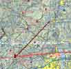 First, establish a new course line. Then, turn the airplane and fly to your
new destination. Specifically, follow these steps, in this order.
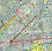 Refine your course
Now that you're headed in the right direction, you can take care of a few things. Estimate your new arrival time and prepare your approach to the new destination. If you decided to divert at all, you probably picked an airport that's not far away, so some rough approximations will serve you well.
If you don't want to drag the plotter out, you can estimate distances fairly well by knowing how big some body parts are, at sectional scale. Your fingers are probably about 5 NM wide. For longer distances, it may be useful to know how far you can spread your hand. Stretch it out on a sectional scale, and remember the distance between your thumb and last fingertip. For most people, this is about 50-60 NM.
The folds on a sectional chart are 35 NM apart.
There are standard sizes on the chart, too. Almost all Class C airspace is 20 NM across. VOR roses, too (they're a bit larger if the VOR is on a Class-C airport). You can measure things by spreading a thumb and forefinger, and transferring your hand to one of these places. This is probably the best way to measure the distance to Stewart. Whatever method you use, you should conclude that it's 30 NM from the X you marked where you began the diversion.
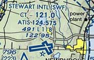 Prepare the approach.
Recognize that you're in range, and complete your cockpit checks for
the approach.
Return to the chart for a moment. Look for things that will help you stay on your new course. At first, the road and railroad between Franklin and Warwick will help you stay on course. The town of Warwick is about 10 NM into the diversion; you should be there five minutes after you turned. Four or five minutes after that, you should cross the 4-lane highway where it curves around a hill. By that time, you should be in radio contact with Stewart Tower, probably with the airport in sight. If they're landing on 27, you're even on a pretty good line to join the downwind leg.
It's said that a pilot is never lost. But there are times when we are temporarily unsure of our position. If we got to Bloomsburg and didn't see the airport right away, it would not be the first time that ever happened. What to do? All of the previous waypoints showed up, right on time.
First and foremost, fly the airplane! This is always your top priority.
If the trip has been going as expected, and it's time to be at a waypoint that you don't see, that waypoint is probably not far away. If it's a waypoint that can't be skipped (like the destination airport), stay where you are. Pick out something on the ground and orbit. Now you have time to think about the situation.
Apply this time-tested rule of thumb.
If the time is right but the waypoint is not found,
your position error is most likely within 20% of the
distance flown since your last known position. In this case, the
In normal navigation, we work from clock to map to ground. That is, when
it's time to log a waypoint, we find a feature on the chart and identify the
corresponding structure on the ground. In this case, the structure appears
to have gone missing at the appointed time, so reverse the process: work
from ground to map. Look for prominent features near where you are
orbiting, and try to locate them within that circle of most probable
location. With the circle of uncertainty, there are several good landmarks:

 If you have a rough idea where you are, you can fix your position from
two VOR radials. Obviously, this is easiest with two VOR receivers, but you
can do it with a single VOR if you're careful to take both readings while
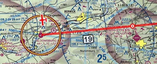
you're over the same point on the ground (orbiting). In this illustration,
our airplane is at the intersection of radials of the Milton (MIP088) and
Hazleton (HZL295) VORs. Draw the two radials on your chart. Now you've
reduced the problem to a diversion (previous section), but the distance is a
lot shorter.

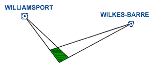
VORs aren't perfect. If the receiver has an error up to 4°, it's still considered suitable for navigation. The transmitter (ground equipment) may have ±1° error. Finally, the pilot might have a bit of parallax error in reading the OBS. So the two-VOR position fix is really a quadrilateral, not a point. Generally, the fix error will be least if the VORs are chosen so that the intersecting lines are as close as possible to a right angle.
 This could be done by taking the fix from the VORs at Williamsport (FQM156)
and Wilkes-Barre (LVZ257). The geometric advantage is somewhat offset by the
greater distance from the VORs, but the basic principle is sound.
With a VOR position fix you are now much more sure of your position. As in the pure pilotage solution, you have reduced your navigational problem to finding your way to a town or airport from just a couple of miles away.